is there a plugin to sync with lat/long map view?
Posted: 15 Aug 2019, 06:24
hi,
i wish to add to every bug a geographic position and show them on a google map (with pin icon).
is there such feature or a plugin to perform that kind ?
Imagine you're a chief of construction and want to collect any problem at several place in the city, we need each bug being associated with a x/y coord position and if we can have a global view on a google map, it would be just PERFECT !
any information of such system with mantis ?
I guess we can add 2 customize user field (longitude + lattitude), but the system to display them such a map remains to develop & code....
i search a system liek that :
red : urgent bug
green : solve
orange : not urgent
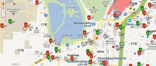
Clicking on a pin would display the mantis detail would be very useful !
Thank you for reading me and ever to reply me or advice.
Have a good day
i wish to add to every bug a geographic position and show them on a google map (with pin icon).
is there such feature or a plugin to perform that kind ?
Imagine you're a chief of construction and want to collect any problem at several place in the city, we need each bug being associated with a x/y coord position and if we can have a global view on a google map, it would be just PERFECT !
any information of such system with mantis ?
I guess we can add 2 customize user field (longitude + lattitude), but the system to display them such a map remains to develop & code....
i search a system liek that :
red : urgent bug
green : solve
orange : not urgent
Clicking on a pin would display the mantis detail would be very useful !
Thank you for reading me and ever to reply me or advice.
Have a good day